Many trails are starting to appear on Google’s mapping data base. I imagine it won’t be long before “all” trails can be found on their maps. Open Street maps has this, which appears to have more than Google: hike bike map.org
Gpsies has the option of loading or using hike bike map as a base layer. If you use Google all you need is a tracker like abvio, who gives the option to use Google as the base layer map (assuming the base layer has the trail you want to follow). Open street maps can be opened in the safari browser on iOS devices. Open touch map might work better in some instances. Go Map!! will let you edit and contribute to Open Street Maps. The Trail Forks app is another great option, but mostly for mountain bikers.
The downside of Google and Open Street Maps are that they require cell reception, and can drain batteries loading and reloading. Avenza and the mtb project app avoid the base layer pitfall by using PDF maps as base layers, but they have to be downloaded prior to adventures beyond cell range. Trail Forks can do the same, it’s a great app. If you plan to be out all day consider something like this so your phone doesn’t die:
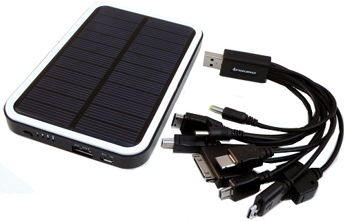 or make your own: Instructables-DIY-Solar-Phone-Charger
Making your own maps isn’t difficult. The maps below were made by downloading the tracks of other people’s uploads of hikes and rides on public forums like Strava, Geoladders, Gpsies, and other sites. Then the tracks were loaded to Google Earth and manipulated (instructions below the sample diy maps). Your location on these Google maps can be shown on your phone assuming you have service. Other applications like MTB Project, Hiking Project, and Avenza use PDF layers so they don’t require cell service, just open sky to “see” satellites assuming you have the PDF layer downloaded. Avenza has most 7.5 minute USGS Topo maps loaded and geo-referenced so you can get those for free, which allows you to make your own tracks and free maps with Avenza..
Stewart State Forest Trail Map, NY:
Trail Mapping Resources

MAPPING and GPS TOOLS
Please consider making donations for some of the “FREE” apps and plugins below if the developers ask for donations.
- Build Your Own Routes/Maps– DIY
- FREE route/course creation: Google Earth | Bikely | Bike Route Toaster | gps upload clunkier creators: Gmap-pedometer | Google Maps (not Google Earth) | Toporoute/Bike Ride Planner
- FREE GPS shape file** converters: Gpsvisualizer | Gpsies | GPS Babel
- FREE Strava converters: Strava Multiple Rider Mapper
- You’ll need this if you don’t have it: Garmin communicator
- Google Earth tools: here
- create course to follow by cutting and joining tracks: bikehike
- Upload data from your GPS device (some of these also feature download options)
- FREE: Garmin Connect | Every Trail | Gpsies | Map My Ride
- FREE, but a fee will get you more features: Geoladders | Strava | Sanoodi | Topofusion | Ridewithgps
- FREE: WP Strava plugin
- More: The 5 Absolute Best Running Apps
- Topographical maps
- FREE and fee: USGS Map Locator
- fee: My Topo
- free: anyplaceamerica
- Fee-based GPS tools
- Sporttracks | ExpertGPS | Gpsbabel | Topofusion (free trial link) | Trimbleoutdoors
- Gravel Map: gravel map.com
- GPS phone Tools
- GarminTM GPS Tools
- Mapping Programs- Base Camp and Map Source
- Apps
- You’ll need this if you don’t have it: Garmin communicator
You can download some of my journey maps from the links on this page
Free maps, map trackers, and map apps:
HOW TO MAKE AND FOLLOW MAPS on your gps unit or phone
- **What is a shapefile?
- How to make a map, or tracks, in Google Earth
- How to load your GPS data into Google Earth
- How to send the map you built in Goggle Earth into your GPS device so you can follow your route on your GPS? Play with the links at Build Your Own Routes/Maps above and use what you like…
- Article on Google Earth use: MTB Action
- Garmin answers some gpx, tcx, crs questions: garmin forum thread
- Premium Strava members can download GPX files from other users to follow on their phone or gps unit
- How I usually make files to follow with a Garmin when I need them:
- Download area routes from Garmin Connect, Geoladders, GPSies, Strava…or any site that has something we want to ride; and/or pull section we rode directly from our GPS unit (with 705, 800 anyway)
- Modify downloaded tracks in Google Earth
- Export/save the resulting track from Google Earth as a kml or kmz
- Sometimes print a map of all the routes in the area as backup
- optional: Run our kml/kmz creation through our % grade profiler to see which way we want to climb/descend (or use Google Earth’s elevation profiler)
- Convert our kml/kmz creations to gpx or tcx files with our own tool, GPSvisualizer, GPS Babel, or GPSies
- Load the gpx or tcx files onto a Garmin
- Pedal, coast, pedal, coast…or left, right, left, right, trip, right, left…
- Get lost?
- Sometimes check a phone backup file of the same route uploaded to Google Maps or Trimble
SAFETY
- Find me spot– gps beacon
- Glymse– gps beacon
- Endomondo– like strava only up to the minute location of where you are
- Road ID
- GPS Status– similar to endomondo
The most pertinent mtb links are on the rides table, but these may also be of interest:
- XXC Mag -dedicated to endurance mountain biking and epic rides
- Gravel Grinder News -un-paved back road oriented events
- Track leaders
- The GPS Geek
- MTB cast
- IMBA Epics
- Bike Packing