HEY, there is a new rating system, and I like it, so think about this for trails: International Trail Rating System
More here: traileaffectpodcast – ITRS
I have a small suspicion that it will go poorly in the US because, well, it’s the US, we often thumb our noses at anything international, and are stupid or stubborn enough to still not use the metric system. Time will tell. Most trails in the US don’t pay any mind to any rating systems, AND are more often than not improperly rated imo, so the blank slate leaves some hope. However, trails get old like people…A blue could become a black or ITRS red with time. Trail maintenance is like exercise or flossing teeth, they should be done, but “it’s convenience we all cherish,” so we throw stuff away or demolish things to build anew so the old can be further neglected and crusty, if not grumpy, or left for dead. Regardless, an ITRS would be nice, and so would the metric system.
At this point in time “most” trails, especially hiking trails, do not have any rating system in place. Signs or markings at “most” trailheads or trail intersections do not advertise how strenuous the trail will be, or what to expect.
There are two main rating systems listed below. The USFS Trail Design Parameters (PDF) are not a rating system, but do provide guidelines for different Trail Classes that could be used for a rating. There are local rating systems as well.
Trail assessment, or some of the techniques of, could help rate a trail. (TRACS, HETAP)
Rating a trail involves some subjectivity or the lines can get blurred when measuring trails and rating them in the field to decide what label to put on the trail, if any. I am often thrown off by ratings, but assume they are only as good or objective as the person rating them, and the methods they use, which sometimes seem way off the mark. Some people are dishonest or fooling themselves, others are just bad at translating what they see and measure. A green trail in New York should also be a green trail in Alabama or wherever, assuming they are using the same matrix to grade the trail. My assumption is that some people must feel as if the trail system they are grading or marking for difficulty needs more than just green or blue trails alone so some systems decide to designate what could be a green trail as blue or blue/green as black etc. Why not grade them as accurately as possible as to not mislead user expectations?
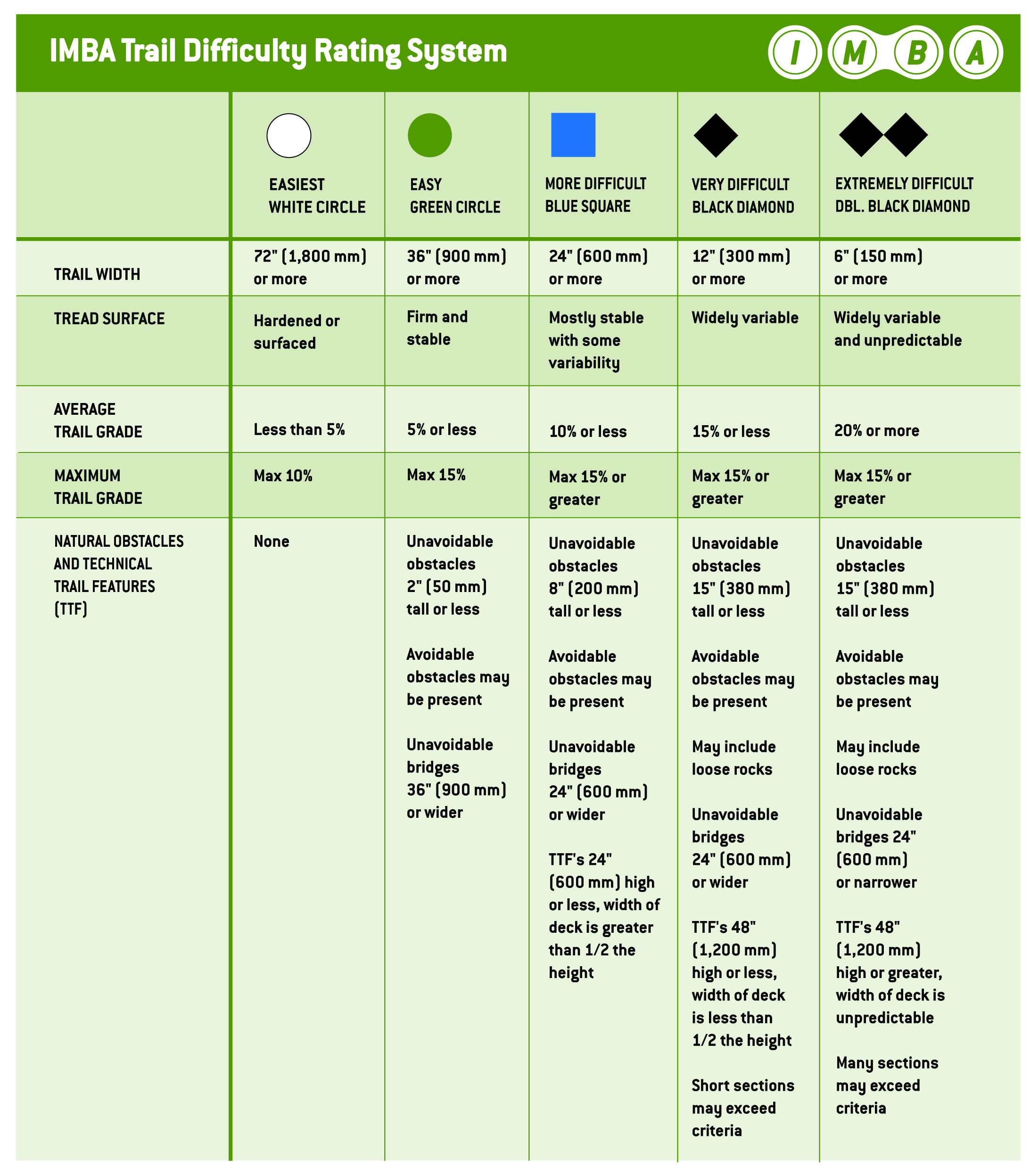
- According to IMBA: about
- SAC Mountain and Alpine Hiking Scale: PDF, also here
- USFS: Trail Fundamentals, Trail Design Parameters: PDF, Trail Classes: PDF
SAC Trail Rating
| Grade | Path/Terrain | Requirements | |
| T1 | Hiking | Path well beaten and marked, terrain flat or moderately inclined, no danger of falling. | None. Suitable also for sport shoes. Orienting without problem, in principle also without a map. |
| T2 | Mountain hiking | A continuous path, generally marked, terrain in sections steep, danger of falling not excluded. | Requires a safe step. Trekking shoes recommended. Basic orientation skills required. |
| T3 | Challenging hiking | Trail not necessarilly visible, exposed passages can be protected with cables, to maintain equilibrium one eventually needs hands, usually marked, a danger of falling on exposed passages, gravel slopes, pathless rock slopes. | A very safe step. Good trekking shoes. Orientation skills required constantly. Elementary alpine experiences. |
| T4 | Alpine hiking | Trail not present, on some places hands are needed to advance, terrain already quite exposed, tricky grassy slopes, steep rocky slopes, easy snow slopes or bare glacier passages. | Experiences with exposed terrain. Stable trekking shoes. Ability of terrain assessment. Good orientation abilities. Alpine experiences. If weather deteriorates, escape can become difficult. |
| T5 | Sophisticated alpine hiking | Pathless, exposed and difficult terrain, on some places easy climbing sections, steep scramble terrain, snow fields or bare glacier passages where there’s danger of sliding. | Mountaineering shoes. Reliable assessment of terrain. Very good orientation abilities. A lot of alpine experiences. Easy climbing skills. Elementary skills of handling with rope and ice pick. |
| T6 | Difficult alpine hiking | Pathless, not marked, very exposed and difficult terrain. Climbing passages up to UIAA degree II. Tricky, steep rocky terrain, glacier with a higher danger of sliding. | Excellent orientation abilities, mature alpine experiences and mastering of handling with alpine gear. |
IMBA Trail Rating