Black Canyon Trail Trip Planning
The Agua Fria river can be problematic. It is crossed just before the Black Canyon City trailhead, and twice after leaving BC City. My main concern in fall, winter, and spring…not having to pack a life jacket or backtrack a long distance to get around the river.
USGS Agua Fria Water Flow Data Updates
- River samples/flow data above Big Bug trailhead:
- River samples/flow data near end of BCT:
- NEAR ROCK SPRINGS, AZ: sample site 09512800
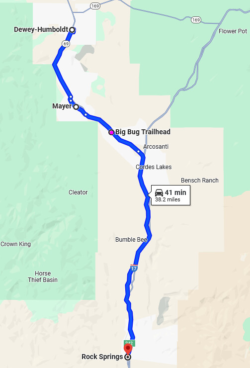
Map for reference of Humboldt, Mayer, and Rock Springs Agua Fria River water sample areas:
Black Canyon Trail Weather Data
DIY Agua Fria River Check Method
The USGS methods above can be skipped, or used as a reference point for observations. It took me a day or two while writing and thinking about this post to realize the possibility of making observations or first hand accounts of the river itself before attempting the long BCT segment from the Big Bug trailhead. An “in real life” opportunity may render the Strava and Traiforks Trail Report methods discussed below nearly pointless. Trail users can check the river just before riding from the north as to avoid having to turn around.
The 1 Mile DIY Agua Fria River Check Option
- Park at the Table Mesa trailhead.
- Walk or ride ~1/4 mile to the Little pan trail and go right to the river for ~1/4 mile on the Little Pan trail.
- Look at the river, done. This location is probably a good indicator on whether the river is raging or not, and if you can cross higher upstream on the K Mine trail (see longer/additional option below).
- The Williams Mesa crossing is downstream from Little Pan a mile or so. Chances are that if Little Pan is passable then the Williams Mesa crossing will be too. The unknown is K Mine, but that is higher upstream and should theoretically be less flow unless the river starts to flow into the ground by the time it reaches Little Pan/Table Mesa.
The 5 Mile DIY Agua Fria River Check Option
A longer option or a second river check in addition to the one above is about 5 miles in length. If you are traveling with 2 cars one group could check each option separately.
- From the BC City trailhead take Skyline for 0.9 miles to K Mine and head north for 1.5 miles on K Mine
- Look at the river, go back to the BC City trailhead ~2.5 miles, ~ 5 total.
Using Strava to see if people are crossing the Agua Fria
If you have a Strava account, a paid account, not the free account, which has less features, the two trails to check for activity or maybe reach out to someone about are: K Mine South north of the BC City trailhead, and these to the south: Skyline, and Little Pan or Williams Mesa. Most people take Williams Mesa.
If you don’t want a Strava account perhaps someone you know has one, or you could do a free 60 day trial and delete it before the payments start. I’m doing the DIY and USGS method because I think that would be fun and more accurate. I don’t have a paid Strava account. Hopefully someone will post a report on Trailforks before I go, but ultimately I’m going to look for myself, it’s only a mile.
It’s hard to locate the BCT on Strava as there are so many BCT and Black Canyon segments on Strava all over the world. A small segment that crosses the Agua Fria might be better than the entire epic, but this could help: BCT EPIC segment on Strava: here
If searching with the Strava segment search box the best luck for the most relevant results is using “Black Canyon City” in the search. It’s still a lot of segments to cull through though. I gave up after 15-20 segment tries. If you found one or two that cross the river comment or drop a line with the contact form.
On Strava if you have a paid account look for the Daily Leader Boards for those segments to see the last time people rode them. The “Local Legend” for the segment or trails on Strava might be able to give you a hint as to the status of the Agua Fria, assuming they want to be bothered.
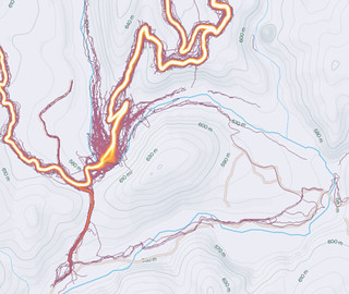
The Strava Global heat map is another way, and free. Zoom into Black Canyon City on Strava to see the BCT cross the river and set the map to “hot” to get a sense of how busy it has been the last 12 months. Regretfully the Global heat map is updated monthly and represents the last 12 months, so it really isn’t that useful except in that it’s a reality check that people turn around or have issues crossing the Agua Fria. Leaderboards for the segments that cross the river are the best you can do to get a sense of if people are crossing the river recently.
If you cross the Agua Fria or see that people have, please check the CFS flow at the links at the top of this page and report back in the comments or drop a line with the contact form.
The Heatmaps are telling. So are the segment searches for Black Canyon City as countless segments start and end at the river rather than cross them! There is a lot of noise at the river crossings on the Heatmaps as you can see below. That noise is people leaving the trail to see if they can cross elsewhere, the threat is real:


The K Mine South Crossing above^ and the Skyline Crossing below:
Using Trailforks to see if people are crossing the Agua Fria
Regretfully I am guilty of not updating trail conditions on Trailforks, but there is a chance someone was patient enough to recently update the trail status on Trailforks to let you know if the Agua Fria is passable. Below the TF segment map is a “Trail Report” list with dates and possibly some info on the trail. Good luck!
If you cross the Agua Fria or see that people have, please check the CFS flow at the links at the top of this page and report back in the comments or drop a line with the contact form.
Segments on Trailforks crossing the Agua Fria:
- North of the BC City trailhead: K Mine South
- South of BC City trailhead: Skyline,
- The two segments above are the key and should indicate if these are passable, but you can check these as well: Little Pan or Williams Mesa
“Many Rivers To Cross”
Creek, wash, and river crossings on the BCT
I believe the Agua Fria is the main crossing to consider, but there are many crossings, and some might be running, though probably passable if the Agua Fria is passable, but don’t count on it.
There are 8 crossings before hitting the Agua Fria heading south from the Big Bug trailhead, possibly more. I don’t personally know if running which ones might serve as an indicator for the flow in the Fria.
- Big Bug Trailhead; Big Bug Creek
- Hackberry Creek
- Cross Antelope Creek Rd; Antelope Creek
- Government Spring wash
- Cross Bumble Bee Rd; Bumble Bee Creek (crossed on Crown King Rd)
- Cross Crown King Rd again; Arrastre Creek
- Cross Maggie Mine Rd; Soap Creek
- Slate Creek
- Agua Fria River on K Mine trail; ~2.5 miles to Black Canyon City Trailhead
- Agua Fria River on Skyline trail
- Agua Fria River on Williams Mesa or Little Pan
Other Maps
There is a CAL TOPO Map of the BCT from a 100 km trail run race- WHICH HAS A FEW ALTERNATES for race aid stations THAT BYPASS THE BCT, but shows all the crossings and has nice contour lines: https://caltopo.com/m/UVSJ5
There is an Avenza PDF map of the BCT if you don’t have Trailforks or want a little better map for airplane mode use: https://store.avenza.com/products/black-canyon-national-recreation-trail-emmitt-barks-cartography-map
Approximate mileage and elevation
| Section | Up | Down | Miles |
| Big Bug trailhead to BC City (first image below) | 2444 | 4626 | 36.2 |
| BC City to Emery Henderson trailhead (second image below) | 2801 | 2549 | 24.8 |
| Totals | 3045 | 7175 | 61 |
The table and maps below are probably close this BCT EPIC segment on Strava, here, but my plan was to break it into two with an extra 1 mile out and 1 mile back in on Skyline to/from the BC City trailhead. 94.52 km is 58.7 miles (the BCT Epic link might be in km)
Profiles from Big Bug to Black Canyon City trailhead by Trailforks segment. Missing from the top image below: Antelope creek, 0.4 mi 6 ft up; Crown King Rd 0.2 mi, 30 ft down.


MORE INFO
- BLM webpage for the BCT
- MTB PROJECTS page for the BCT
- Trailforks for the BCT: ride without shuttle; BCT map segments
- Singletracks 2024 article on the BCT
- Black Canyon Trail Coalition