Some of the links in the table below have maps, gps tracks, photos, and sometimes stories to go with them. There are a number of trails with gps tracks and geo-tagged photos below this table. I’m bad about keeping the table current, but I’m slowly catching up. The map is a little better.
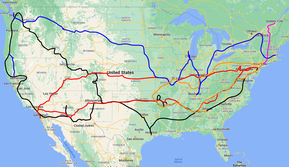
The map below is still being populated, but gives a general sense of the depth and breadth of my trail travels.
State |
City |
Hike |
Ride |
Alabama | Anniston | Coldsprings Flow | |
Pelham | Oak Mountain | ||
Arizona | Flagstaff | Shultz, Moto | |
Elden | |||
Prescott | Lynx | ||
Tucson | 50 Year | ||
Phoenix | Estrella | ||
Arkansas | Syllamo | ||
California | Escondido | PCT Sunrise | Elfin-Hodges |
Escondido | Santa Fe- Del Dios | ||
Livermore | Del Valle | ||
San Luis Obisbo | Morro | ||
Loma Linda | Hulda-Cooks | ||
Big Bear | |||
Mt.San Jacinto | |||
Colorado | Fruita | 18 Road | |
Fruita | Kokopelli | ||
Buffalo Creek | Scraggy | ||
Georgia | Amicalola Falls | 400+steps | |
Missouri | Potosi | Berryman | |
Nevada | Boulder City | Bootleg | |
Blue Diamond | |||
Cowboy | |||
Cottonwood | |||
Bootleg | |||
New Jersey | West Milford | Pump Track | |
Jungle Habitat | |||
Surprise Lake Loop | |||
New York | Devil’s Path | Blue Mtn | |
Long Path/Woodbury | Bear Creek | ||
Sterling Forest | Stewart | ||
Storm King | Ellicotville | ||
Schunemunk | Waywayanda | ||
Minnewaska | |||
North Carolina | Tsali | ||
Kerr-Scott | |||
Ohio | Mohican | ||
Ray’s | |||
Pennsylvania | Boulder Field | Allegrippis | |
Merli | |||
State College | Roth Rock | ||
Rattling Creek | |||
Thorpe | |||
Tennessee | Tanasi | ||
Utah | Hurricane | JEM, Goulds | |
Vermont | Green Mountain Trails | ||
Kingdom Trails | |||
Virginia | Douthat | ||
Indian River | |||
Shenandoah Mtn |
Geotagged Photo Trails
Most of the mountain bike rides and hikes below have photos along with the gps shapefile thanks to a nifty process developed by Geoladders. In turn, you can see the pics on a map if you hit the “player” function (sample). If you login to Geoladders you can view the gallery and direction shots in their entirety to get multiple trail-eye view shots. If you explore my geoladder account you’ll see lots of hikes and rides without photos that may also interest you. Or you can check my Strava account, though it doesn’t track my hikes well because I don’t pay for a premium membership, and it only tracks riding and running. You have to login to Strava to follow me. You can email me if you have questions about one of my hikes, rides, or trail work adventures.
The list of 4 rides below don’t have photos, but they incorporate many San Diego parks into big loops and point-to-point rides. I developed the routes with a friend, which took several years of reconnaissance. We made a sister site to house the routes, but now they live here on this site:
Geoladder routes with photos (CA, NV, PA, AZ):
San Diego Trails
- Scripps and Poway Area
- Carlsbad
- La Costa and San Elijo
- La Costa | another version some things have changed since these uploads
- La Costa + San Elijo
- San Elijo DG
- San Elijo Loop (4-1 tracks)
- San Marcos- Frank’s Peak
- Lake Hodges
- East Poway(ish)
- Far East County
- Big Laguna
- Big Laguna Epic
- Similar to route above (only one photo)
- Sweetwater area
- Sweetwater to Otay loop
- Spanish Bit Trail (CA ride/hike trail)
- Sloane Canyon to Fence
- I have some other rides (Sweetwater Epic 35) that may be of interest (Sweetwater lolipop21), otay lake loop small,otay to hollenbeck
- Hollenbeck explore
- Ramona
- Elfin
- Downtown
- Cuyamaca
- Cuyamaca
- Cuyamaca Max 1 Track
- a lot has changed out here (new trails etc.) see these also: 1, 2
- Black Mountain
- Black Mountain Park- Triple Loop
- Black Mountain/De Luz Preserve Loop
- There are new trails here as well
- Other SD rides
- Viejas (think this is usually off limits Native American land)
- Margarita Truck trail (8S02- Cold Springs Rd.)
- Palomar Mtn.- Boucher Peak via Nate Harrison Grade
- Archipelago (route has changed to something better, and some sections in this version are no longer passable)
- P mountain (not “Palomar”)
Los Angeles
Orange County
San Bernardino
- May Valley Maze-Idyllwild
- Hurkey and May Valley
- The Exploration Trail- Big Bear(Arrowbear)
- also of interest: Alvin, Alvin Meadows…lot o’ 1 track, SART post office loop to 38 @ 7 Oaks
Nevada
- Bootleg Canyon- Westside Tour
- Late Nite/Blue Diamond ‘tour’ (no pics)
- Cottonwoood- Dead Horse Loop (w/ NORBA section)
- Cowboy Trails- ‘Triple Lasso’
Arizona
- Fisher Point- from Cocconino CC
- Fort Valley- Lower Moto 8 Loop
- Fort Valley- Lower Moto-Schultz
- Rockridge-Oldham- Flagstaff
- Mt.Elden (Rock-Brook-Sunset-L.Bear-Schultz)
- Campbell Mesa- Flagstaff
- Lynx Lake (Trail 305)- Prescott
- Fantasy Island (All loops but Valencia)
- 50 Year to Chutes from Catalina Park
- Charouleau Gap (4×4 Rd. #736)- Tucson
- Estrella Mtn. Race Loops– Long Loop
- McDowell Mtn. Park– Sport Loop
- McDowell Mtn. Park– Long Loop (Cactus Cup)
- McDowell Mtn. Park– Technical Loop
Pennsylvania photos to be loaded later