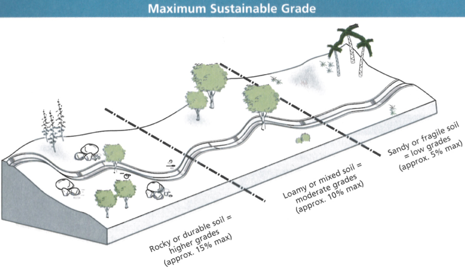
Most sustainable trails are 10% or below for long runs with *frequent grade reversals within the same percentage range. Shorter 15% sections are permissible, and sometimes up to 40%+ depending on soil/rock conditions, routing, weather, user groups and numbers.
Half Rule
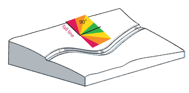
Most sustainable trails also follow the “half-rule,” where the trail grade is less than half the side slope it crosses (half rule for running slope = < fall line or side slope/2). The “fall line” is the line a bowling ball would take if you let it roll down the hillside the trail is supposed to traverse. It is best to bisect the fall line by less than half the fall line’s percentage.
Something to consider is that when surface and subsurface water go from upslope down the backslope and then hit the trail…it slows down. Question is, will it slow and follow the outslope of the tread or start running down the trail? On “narrow” trails it is more likely that most water will make it to the edge of trail (with no outside berm) and leave the tread and head down the mountain/hill. On wider trails it may stay or begin to flow down it, especially if the running grade is steeper than the outslope. So on “wider” trails its better to have steeper outslope (that may even match grades), more frequent grade reversals, and/or softer grades than outslopes to deal with this issue. In my opinion, outslopes over 15% can start to feel weird. And considering the info below, its not necessarily a good thing to go much steeper than 15% for long anyway. Of course tread widths are never that long unless we are talking about roads or roads people call trails (troads).
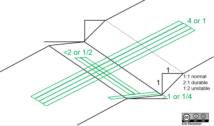
Outslope
The outslope of the tread could follow the half ‘rule’ or suggestion, but the running tread now becomes the sideslope, and the outslope the grade (half rule for out slope = > running grade/2 or > fall line or side slope/4).
- The USFS recommends “at least 5%” outslope. I believe at one time I saw a 6 to12% recommendation from the USFS.
- The USFS Accessibility Guidelines put outslope (or cross slope) at 2-3% for a Class 5 trail, which has a max grade of 5%.
- For steeper trails, like a Class 2 hiking trail, the target grade is 5-18%, max 35%, outslope 5-20%!
- Going past 15% outslope trails start to feel off-camber, and look it too, as there is almost a 2 inch difference between the inside and outside of the tread on a 12 inch wide trail (12 in. x 0.15 = 1.8 in.).
> If we used the half guideline, which is nearly what the USFS Trail Classes do, and also assume max grades are to be about 15%, then a standard of about 8% outslope could cover most trail grades (1 in. for a 12 in. tread). However, if we want “all” the water to sheet directly across the trail and not begin to travel down it then the outslope should be greater than the trail grade, meaning for 15% grades a >15% outslope. But with this outslope it can feel awkward to walk, and in reality staying near 8% should suffice. Water may start to travel diagonally across the tread, rather than straight across it, but it won’t make it too far before leaving. We can assume it will travel at about 45 degrees across the trail if the outslope is near half the tread grade. Rocks and maybe roots in the tread can help by stopping down trail water movement.
$latex Half\;Rule=Slope\;Grade\leqslant\frac{Fall\;Line}{2}&s=2$
$latex OutSlope\;Half\;Rule=OutSlope\;Grade\geqslant\frac{Fall\;Line}{4}&s=2$
or $latex OutSlope\;Half\;Rule=OutSlope\;Grade\geqslant\frac{Running\;Grade}{2}&s=2$
Inslope
Quite often at higher elevations, or in general where soils are thin before hitting bedrock, it is much more practical and sometimes necessary to inslope trails rather than outslope them. This is primarily because seeps are more likely to follow bedrock to the backslope and seep out or daylight, keeping an outsloped trail too wet to ever dry in some circumstances. Therefore these type of trails have interceptor drains at the hinge and really inslope towards the interceptor rather than outslope away from the backslope. Not only that, but in some rocky terrain this provides a little more soil for the tread, or insloped tread. Besides the senario just described, inslopes are much more common on bike trails to help guide bikes or catch them. It’s simply an action-reaction situation, or Newton’s Third Law, played out in sculpting the trail to guide a bike’s momentum and next trajectory. If done subtly enough as to not to roll ankles its also great for trail runners and hikers as the trail tends to have more “flow” for multiple modes of transport. The same thing is done on roads, especially on and off ramps or high speed curves. A little inslope goes a long way to fight the friction coefficent being insufficient to keep all 4 or 18 wheels on the road.
Backslope
Back slopes should be as soft and close to possible as the uphill slope. It could be ~1:1, 2:1, or 1:2 (rise:run) depending on soil/rock types. Being that cutting bench takes away mountain, the backslope will always be steeper than the upslope, but softer is better. The best bet would be to get it to the angle of repose for that soil type, but ascetically it should fade into the upslope from the hinge of the tread.
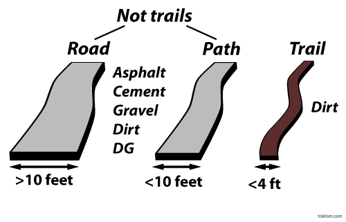
^Maybe I’m being a little silly with that graphic, but that sums up my disdain for calling roads (troads) trails. I refuse to buy into that language and hope you help me stop roads from being defined as trails and co-opting what a trail experience is. We can go back and forth about 3, 4, or 5 feet wide all day, but I’ll return to grades, not widths, there is more on the width issue elsewhere on the site.
Rules vs Guidelines
All the aforementioned ‘rules’ are not “specs,” but general “guidelines,” that can be surpassed; however, its not recommended if the character and longevity of the trail is important. These recommendations are set because it is the laws of nature, mainly the interaction of water and gravity, that revealed these guidelines to us. Go outside these bounds and the nature of the trail will die, sometimes quickly, because the laws will break the disobedient trail and there is no escaping this unless you pave it. In that case maybe we no longer have a trail.
By “frequent”* it is implied that grades are reversed for 10 to 15 feet or more, then “rolled” back over to resume descents, placed every 20 to 50 or more feet depending on grade and soil (see below). In lieu of reversals, sections of trail (10-15+ ft long) where the grade is less than the out slope can also be used to move water off the trail, e.g. running trail slope 3%, side slope 7%(hillside), and tread out slope 5%.
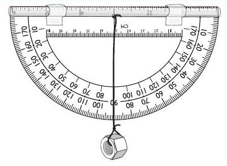
Rough grades should be laid out near 10%, or less really, to give some room for dealing with reroutes to cope with unexpected issues like bed rock, and seeps etc. Clinometers are good for fast rough grade layouts and flagging. Then a cheaper and more accurate tool for fine-tuning rough flagged layouts and reversals can be used like a 50 or 100 inch straight edge with a level on it, a SmartTool level, or M Level.
Why care?
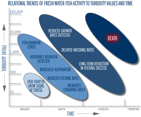
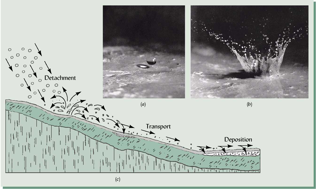
Soil erosion off trails causes turbidity and affects fish and aquatic life.
Increased turbidity
-Decreased sunlight/photosynthesis
-Decreased vegetation, and diatoms
-Decreased oxygen
Increased Sediment
-Smoother water bottoms
-Reduced turbulence
-Reduced oxygen
-Possible phosphorus boost
Increased Organic Matter
-From turbidity killing plant life
-From direct OM input
-Both feed anaerobes, reducing oxygen
Poorly laid out trails kill!
Grade Reversals and Erosion
The distances between grade reversals have not been researched scientifically as far as I know, i.e. peer reviewed and published in a scientific journal. Trail grades have, but of course grades alone don’t tell the story as a gentle grade at 5% and no reversals won’t last as long a steeper trail, at say 15%, as long as it has “frequent” grade reversals.
I find it hard to believe that given the amount of soil research done over the past century such information doesn’t exist somewhere. I’ve searched high and low for some time, but haven’t found this data. There are some farm/crop erosion models using the Universal Soil Loss Equation, but this is more for tilled or fallow fields than compacted dirt roads or trails as far as I know.

The best solution to answering how far to place grade reversals is to hike trails and pay attention to the type of erosion taking place. Bring a tape measure and level to measure the running grade and tread out slope (as well as a bag to test the soil type so you can share your findings with the world).
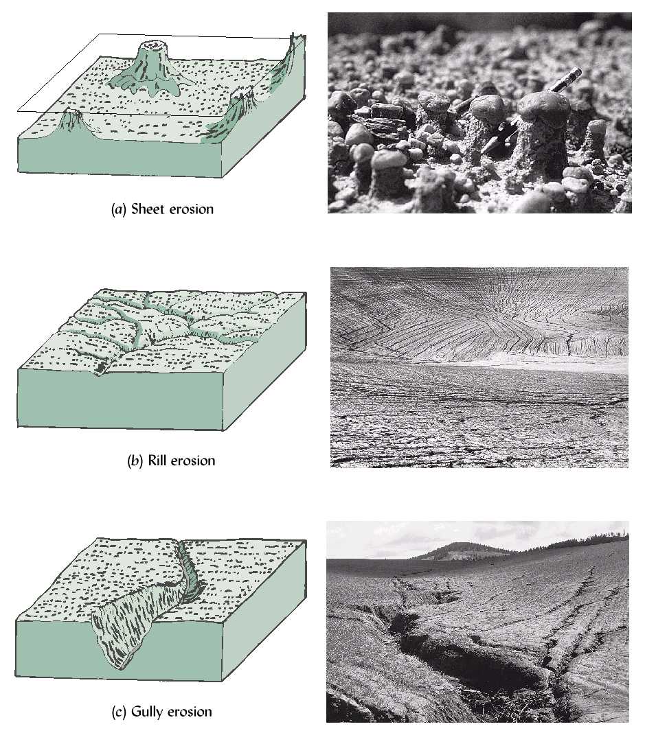
Look for signs of sheet and rill erosion and note the grades where this happens. Most importantly note the distance at which sheet erosion takes place. This is about the limit of where grade reversals should be at the grade witnessed, given the soil type. You might not see rills, and sheet erosion is hard to see, deposition is easier to spot than sheet erosion if no rills are present. Note the grades and distance between grade reversals* where deposition is occurring as well. Also note the distance and grades between successful grade reversals. In the end you should have a picture of appropriate grade and distance limits between reversals in your area, and soil conditions. (*by grade reversal, I mean a grade change that will cause water to leave the trail: root, rock, water bar, grade dip, rolling grade dip, or grade change flip, or reversal from positive to negative, or vice versa) This USFS document is helpful for erosion assessment ideas: http://www.fs.fed.us/rm/pubs/rmrs_p015_5/rmrs_p015_5_133_140.pdf
One source of “data” for grade reversal distances is only observational, NOT SCIENTIFIC, as far as I know. In that sense, perhaps it is not “data” at all. This information is summarized in the table below. “PA” refers to Pennsylvania Trail Design & Development Principles, “MN” refers to Trail Planning, Design & Development Guidelines, and “TSP”(Troy S. Parker) refers to Natural Surface Trails by Design. Note that Parker helped write the MN book– and it’s quite obvious as the table shows, although in the MN book some numbers were dropped. Also note that no research technique was sighted, only that observations were made. Furthermore, according to Parker the numbers are “hypothetical,” and a “conceptual guide” where “conditions and results will vary.” Not to bag on Parker, but why make the table at all, or include numbers if its “hypothetical”? “Results will vary” if “conditions” do is a syllogism, but just what is stipulated by “conditions” is not apparent. I’m guessing “results” means the hypothetical numbers. Perhaps he’s covering his ass to some degree, not sure. Then again, he uses “0%” to represent “0 to less than 2%.” I’d say that’s a hypothetical view of what 0 means. I’ll grant that a completely level 0% segment is hard to obtain (or make last) in nature, and that “0 to less than 2″ could be called “flat.”
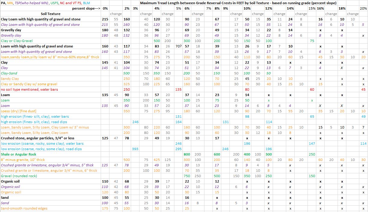
Excel document of the image above.
Parker was not involved with the PA book as far as I know (according to the acknowledgements), but no sources or techniques were sighted for the PA “data,” if it really is data in this case. Note some of the discrepancies between PA and MN as well. I’m doubting they used Parker’s numbers. What is odd though, is that MN does not include 0%, thank goodness, but PA does (like Parker does in his book). Why? PA does not state that 0% represents anything else, so I’m guessing it means 0%. How in the hell you have a grade reversal between 0 and 0 is beyond me. At least Parker indicates that his 0 means “0 to less than 2.” My own observations are like Parker’s, just observations (in Carlsbad, CA to be exact with variable out slope between 5-10%). I’m guessing the USFS has some real data and hard, not hypothetical, numbers buried somewhere. USFS or elsewhere, I haven’t found them (yet). I have included some USFS info from the Forest Service Trails Handbook, The North Carolina Forest Service, and Vermont Forests, and Park and Recreation. I do not know if these sources are anything more than anecdotal, like Parker and the PA information. Only the USFS includes soil types.
Please keep in mind that tread out slope (and compaction) can change all of this distance information dramatically. PA does not note out slope percentage, MN/TSP put tread out slope at zero, or no out slope. The USFS, North Carolina, and Vermont do not mention out slope percentages.
In the end, the best thing to do is visit trails and dirt roads in the area to record your own observations, and don’t forget to note tread out slope. How to determine soil types is detailed a few paragraphs below.
Instead of making trail layout a difficult process looking for how far to push grade reversal distances according to soil type, the safe and easy approach, or best practice, may be to do what IMBA and the USFS recommends: place grade reversals every 20-50 feet and keep out slope properly set, or according to the USFS, “keep grades sustainable by using the half rule and add plenty of grade reversals”(source). I’m not sure what “plenty” means. Both approaches seem to be a ‘might as well be safe’ approach. Why push the limits and be sorry, or worry about soil types for that matter? The only thing I don’t like about the IMBA approach is that if ALL trails followed this rule they would all start to feel the same. Sure rhythms could be broken up into different patterns, but the meter of 20-50 would always be nearly the same. One way to break up the meter could be flat(ish) spots between the 20-50 rhythms, and leaving some rocks and roots if possible. Regardless, grade reversals are necessary to ensure a trail stays for years to come rather one that washes away.
Another general guideline from IMBA:
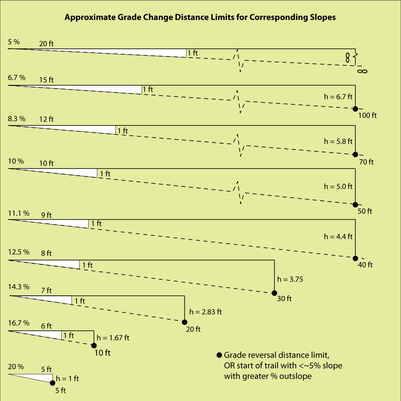
The distances in the table below are “limits” to running slope lengths between grade reversals (or nearly flat sections of trail with sub 5% slope) in Carlsbad, CA.

note: Forest Service Trail Accessibility Guidelines (FSTAG) 7.4.3.2 “The cross slope [out slope] shall not exceed 1:20 (5 percent). Where the surface is paved or is elevated above the natural ground, the cross slope shall not be steeper than 1:48 (2 percent).”
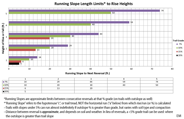
^The so-called “limits” (in sandy Carlsbad, CA with variable out slope between 5-10%) are graphically displayed above, note how some grades are missing as heights increase.
A pictorial representation of the graph above:
^ This distance will vary based on soil type, vegetation, and precipitation norms. It is best to seek local dirt roads or trails to observe what grades and widths start to cause rivulets and where.
Grades and Bike Speeds
This is probably one of the most important visual representations of the “mathmagical” concept of energy conservation in trail building with bikes in mind that I have made. It’s not as much about the graph as it is about the concept of the conservation of energy and how we can use it to enhance rider experiences using gravity to control speeds as we wish. It’s not magic, but a depiction of, as my “trailscendentalist” friend’s email handle read “mathmagical” reality.
Consider the graph below and the grade and erosion graph up above, make sense? Also consider that water will probably move slower, I haven’t figured out just how much slower as fluid dynamics is no joke very complicated, but suffice to say, water is very powerful and will carry trails away fast. It doesn’t take much. The point here though is that we can use grades to control speeds, and lift people off the ground too if we want. Also note that this is coasting, with pedaling riders can go faster, so we don’t need much grade to go fast, or too fast without user conflict.

USFS grade guidelines by Class and Use Type:
- Trail Fundamentals
- National Design Parameters PDF DOC
- Trail Class Matrix PDF DOC
- Accessibility Guidebook for Outdoor Recreation and Trails
Water Bars
I hate to end with a word on water bars, but when grades do start to exceed 15-20% for long, especially on hiking only trails, a water bar and/or check step (with a base step) might be the best option assuming there is rock available (preferably rather than wood or old school rubber chevrons).
Pingback: San Jacinto Peak, Southern CA’s Second Highest | Trailism
Pingback: Skidding Culture Idiocracy | Trailism
Pingback: Skidding Culture is Not Stewardship – Trailism
Pingback: San Jacinto Peak, Southern CA’s Second Highest – Trailism