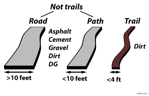
Many trails plans begin by using old dirt and gravel roads that served a myriad of purposes, quite often for resource extraction in mountainous regions. If you happen to be in the Hudson Valley area some “trails” are carriage roads, others Revolutionary War or Native American routes. Some of the routes, or portions of them, make good road to trail conversions, while others are not sustainable in the long run. Those portions are better left for closures and reroutes (if feasible). Some of the roads maintain there road character and corridor, and others disappear into the landscape if converted to a narrower corridor with help from mother nature and users meandering subtly on the bench.
The scale of Forest Service roads is enormous, there are more Forest Service roads than miles of highways.
According to the Federal Highway Administration there are over 1.4 million (1,417,904) miles of unpaved roads in the United States, over 1/3 of the U.S. total (1 2012).
For comparison sake, the Interstate Highway System is approximately 164,000 miles, about 1% of all public roads, 65% are in rural areas.
The National Forest Road System consists of more than 380,000 miles of roads. The types of roads range from permanent, double-lane, paved highways to single-lane, low-standard roads intended only for use by high-clearance vehicles, such as pickup trucks. At this time, a significant portion of this system is closed or use-restricted to protect resources…
There are also more than 60,000 miles of unclassified (unauthorized) roads on National Forest System lands that have been developed over time by users outside the forest planning process that do not meet technical standards or environmental protection standards. These unauthorized roads may present an environmental threat and a potential safety threat to users…https://www.fs.fed.us/eng/road_mgt/qanda.shtml
The Forest Service has a growing $8.4 billion maintenance and reconstruction backlog and receives only 20 percent of the annual maintenance funding it needs to maintain its existing 380,000+ mile road system to environmental and safety standards.
That last paragraph is telling. The same could be said for some trails, especially trails shoehorned into or onto abandoned or failing old roads. Where am I going with this, nowhere perhaps. Some of the roads should, or could, double as connectors to trails or paths, others not. There certainly appears to be no shortage of them. Like most trail design problems whether a road will make a good trail depends on many factors, and leaves many questions from weather, to soil, to safety, to historic value and more.
“I would go into a town and ask the local people, ‘What’s the oldest route from here to there’,” he said. “And it worked, because the local memory of these paths still exists.” Caselli walked all the way from Canterbury to Rome, crossing the British countryside, the English Channel (by ferry), French Champagne country, the Swiss Alps and the rolling hills of Tuscany.
http://www.bbc.com/travel/story/20181203-a-1000-year-old-road-lost-to-time
…[I]ndigenous footpaths, for centuries not much wider than five or six feet across, were some of the first roads in Chicago to be widened and normalized… Native people taught incoming white settlers these transportation routes, as well as giving them snowshoes, canoes and other transportation tools – necessary equipment as white colonizers spread further west.
https://www.theguardian.com/cities/2019/jan/17/native-american-routes-the-ancient-trails-hidden-in-chicagos-grid-system
How many of the roads and trails we now travel were Native American is hard to say as some are lost to history (see this post for more:trail marker trees). Many of the more notable routes throughout the world can be found here: https://en.wikipedia.org/wiki/Historic_roads_and_trails
As we venture into the future I doubt much will change. We will continue to use roads to get to trails, and convert some roads to paths and trails. Sometimes they work well as trail corridors, sometimes they are better off left to die than live.
MORE ON ROADS (and trails):
- https://gravelmap.com/
- Forest Service Road Maintenance Series: Smoothing and Reshaping the Traveled Way You Tube
- Forest Service Road Maintenance Series: Maintaining the Ditch and Surface Cross Drains YouTube
- Interactive Travel Map | United States Forest Service
- Special Practices for Design and Construction of Subgrades in Poor, Wet, and/or Saturated Soil Conditions: https://www.lrrb.org/pdf/200336.pdf
- “Our Roads Are In Bad Shape…why Spend Money On Trails?” https://www.americantrails.org/resources/faq-our-roads-are-in-bad-shape-why-spend-money-on-trails

In 1915 the Forest Service publication, Trail Construction on the National Forests, discerns the two types of trails: “Mere ways through the forest, whether marked or not, are not regarded as trails; they are matters of woodcraft rather than of permanent forest improvement. A trail is a narrow highway over which a pack animal can travel with safety during the usual period when the need for a highway exists.”
http://www.foresthistory.org/ASPNET/policy/Recreation/trails/TrailBuilding.aspx
Call me a pack animal, and call single track a trail.