The plan…hit as many “Epics” and the like as possible on my way East (and my way back West (to be continued)):
A: leave this town…with a heavy and light heart…
B: Hurricane Cliffs, UT– “edge of the Colorado Plateau and the Great Basin. Grand mesas, vertical rock formations, and deep canyons combine with extinct volcanoes and vast rolling arroyos, bringing together a taste of all that southwest Utah’s Color Country has to offer. The Hurricane Cliffs Trail Network strings together a 21-mile loop, formed by four segments: the Hurricane Rim, JEM, Gould and Gould Rim trails.”
C: Good Water Rim, UT– “This is one of the best rides in Utah. The 15 miles of singletrack follow the edge of Good Water Canyon…great views, coming so often you’ll stop looking! As a loop, the entire ride is 21 miles…There are no sustained climbs, but the trail has frequent little dips and endless twisting turns…the singletrack hugs the edge of the many side-channels that feed into Good Water Canyon. Good Water is a short steep-walled side canyon off The Little Grand Canyon of the San Rafael River.” map gpx, and photos
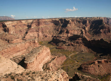 Good Water Rim^
D: Fruita, CO- The Edge Loop– “A steady one-hour climb delivers you to this fascinating viewpoint. East and south loom the mighty snowcapped Rockies. The canyons, arroyos and red rocks that mark the beginning of the great American desert unfold to the west. There is nothing to do but stand in awe, and then head DOWN. Tight, slalom-like singletrack defines The Edge Loop and guarantees ear-to-ear grins.” Fruita Blog Post
I may stay another day to do some other rides, as there is so much in Fruita…high on the list is Mojoe.
E: Eagle, CO. Sylvan Lake…Returning to complete the ride that got cut short in 1995 when I broke my neck…on a log that is still visible on Google Earth! Might just bring a chainsaw.
Sadly, I pressed for time to get out of the mountains due to snow, and not wanting to miss Buffalo Creek, I never got to do this trail…TBC.
see it crossing the trail^…pretty sure that’s it as it was in that meadow. I’ll know in a few days. I have to do this. Hopefully it’s still open to bikes.
F. Buffalo Creek Trails, CO– “Buffalo Creek trail system features smooth, rolling singletrack and lots of variety. The area has been damaged by forest fires recently, but you’ll witness nature’s ability to rebuild itself. The diverse trail system meanders through areas unaffected by fire, as well as surreal, barren landscapes still rebounding. These are among the best trails in the greater-Denver region.”
G: Wilson State Park, KS– Switchgrass Trail. Kansas, really? I wanted to go through Nebraska to hit Potters, and Sugar Bottom, but opted for this instead- “a true backcountry mountain bike trail featuring diverse natural beauty and challenging trail features, complemented by lake views, sandstone formations and a trailhead with all the desirable amenities…Since 1995, Kansas Trails Council (KTC) leaders have utilized their hard-working volunteers, generous private donations, a Subaru/IMBA Trail Care Crew educational visit and a Department of Transportation-Recreational Trails Program (RTP) grant, to grow this gem beyond 20 miles of well-planned, sustainable singletrack that is regularly raced on and groomed by the KTC.” Switchgrass Blog Post
H: The Berryman Trail, MO– “Located in Mark Twain National Forest on the low shoulders of the ancient and gnarled Ozark Mountains, Berryman offers classic Midwestern mountain biking.
Traverse from woodsy creek bottoms to ridgetops on tight, rocky singletrack. You’ll pass a cave rumored to be the hiding place of notorious Old West outlaw Jesse James and his gang. The route mixes narrow toboggan-run descents, rock gardens and twisting, bench-cut singletrack as you curl back to the Brazil Creek campground.”
I: Brown County State Park, IN – “This is flowing singletrack at its best, built in one of the largest contiguous hardwood forests east of the Mississippi River. The trail designers used every bit of the 600 feet of elevation change available to create five independent loops and three connector trails.” Didn’t make this due to unfavorable trail conditions so I pushed forward to an unplanned Ohio instead.
J: Raystown, PA– Bet and I had the pleasure of riding Raystown/Allegrippis (track link) and Rattling Creek a year ago (video). It’s going to be extremely hard to pass Alley as it is so awesome. I want to ride Roth Rock and Alley, but I may have to cut it out as I’ve already ridden it. Rode it, see blog post here.
K: Roth Rock, State College, PA– “The country’s oldest stand of hemlocks, protected here in the 90,000-acre Rothrock State Forest, are a defining highlight of the Roth Rock Ride. Another is the rocks. “Tombstones,” as they are called by some, are the awkward-shaped stones that stick a few inches out of the ground at all angles.”
L: visit with ‘family’
M: My trail work home for the next 6 months…TREES! I miss trees.
N: Not on the map above, but Kingdom Trails is certainly on my list of places to visit while posted in NY. I made it.
I’m going to hit as many Happy Cow sites as I can on the way as well…oh boy! If only Travis, my travel partner from the Wilson Tour was with me to do it again. Actually he opted out of my restaurant hops 99% of the time.
Fourteen days is the plan, but I’m not sure if I’ll pull it off. I planned ambitiously as a back-up, and intend to do the best I can to make it happen, but I may have to cut a few rides out, or make them shorter than planned mileage-wise.
Trying to sell my old rig and build a new, but something tells me I’ll be taking the bike I have as time is running out quickly. I want to do the DC before I go, but don’t know if I’ll have time. When I get back I should be in prime shape to whip it out in two, maybe 1 day (but still doubting the latter).
Thanks to Geoladders and this Strava converter for helping guide me: http://cosmocatalano.com/strava/export/index.html. I’ll be loading all the gps tracks soon. (it appears that the converter no longer works…luckily I got to use it before Strava changed the API)
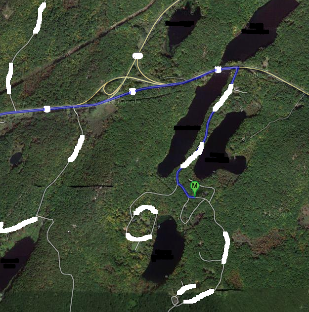
The map below shows most of the the stops I made. map link
The pins in the map below are at the trail head location FYI. I do recommend MTB Projects as they have some of these trails mapped (some helpful, some not). I have posted maps (and gps tracks) in the linked posts above as well.
Pingback: The Epic Mountain Bike Journey West- Part 2 | Trailism
Pingback: Allegrippis, Raystown Pennsylvania | Trailism